They've Had
Their Chances.
Now It's Ours.
Pharrell Williams had a plan. Emmitt Smith had a plan. Bruce Thompson had a plan. Every one of them wanted to buy the land. The city shelved all three — then proposed a library and a fitness center. Placeholder projects. A signal that no one in City Hall has a real vision for this site.
The Eastside Civic League named it correctly in March 2025: "Downtown Tunnel Vision 2.0." Another round of resources flowing toward downtown while the Eastside gets managed decline dressed up as investment.
"The highest ground in a flooding city should be where people live — not where a failing mall sits half-empty."
Why This Moment Is Different
Military Circle sits at the highest elevation in Norfolk — a city sinking 4–5mm per year. Every proposal has circled this fact without saying the obvious: this land should house the people who will be displaced by flooding everywhere else. The commons argument and the climate argument are the same argument.
What the City Needs to Do
Site plan opposite: 19 confirmed EDA-owned parcels (73.4ac), real Norfolk GIS geometry. 5,118 units · 96% affordable · $43.5M/yr NOI at stabilization. Full interactive plan + financials: jason-edelman.org/eastside-commons
Eastside Commons
20 years. 5,118 homes. 96% permanently affordable. Ground leased forever.
Housing Mix
Six Structural Commitments
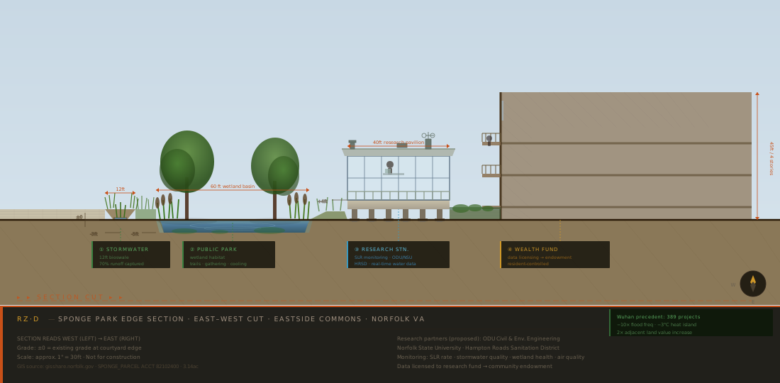
Section: Sponge Park Edge (RZ·D)
The City Holds the Land. Forever.
Every developer wanted to buy the land. Once they own it, your negotiating power is zero. A Community Land Trust breaks that cycle: buildings go up, people move in, but the land never leaves public hands. When ground leases expire, the community renegotiates from power. The appreciation stays in the commons. That is the point.
Wuhan Showed What's Possible
Wuhan's sponge city program: 389 projects, 38.5 km². Flood events reduced 10×. Urban heat down 3°C. 725 tonnes CO₂ sequestered per year. Adjacent land values doubled. The sponge park at Eastside Commons stacks four functions on one parcel: stormwater capture, public wetland park, sea level research station (ODU/NSU/HRSD), and community wealth fund via data licensing.
Get Involved
Liz Albert · (757) 681-0131
Rosemont / Forest Shores / EP Civic League
Edith Lizalde, President
Ward 4 City Council
JP Paige, Representative
Full plan + GIS site map
jason-edelman.org/eastside-commons
GIS data: gisshare.norfolk.gov + data.norfolk.gov FY26 Assessment. 19 EDA-owned parcels, 73.4ac. Flood zone X (low-moderate, FIRM 2017). Ward 4 · Military Circle Civic League · Planning District 87. All site plan geometry derived by constraint satisfaction from parcel data. Draft for community discussion · 2025.
The High
Ground
Is Ours.
73 acres of city-owned land at the highest elevation in a flooding city. A 20-year commons master plan.